Thursday, September 26, 2013

Choose your shelter in Georgia!

Depending on the weather, terrain and just how far I feel like hiking, there are plenty of shelters along the way.

After leaving Springer Shelter, the following shelters are along the way.

2.8 mile mark Stover Creek Shelter. An alternative if Springer shelter is packed.


8.1 mile mark is Hawk Mountain Shelter.


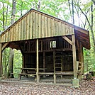
15.8 mile mark Gooch Mountain Shelter.


28.1 mile mark  Woods Hole Shelter  Requires a bear resistant canister to camp there.
mm 3.6 Woods Hole Shelter. GPS N34.7372 W83.9549  Courtesy pjwetzel@gmail.com

29.3 mile mark Blood Mountain Shelter.  Requires a bear resistant canister to camp here.
Blood Mountain Shelter from Abov

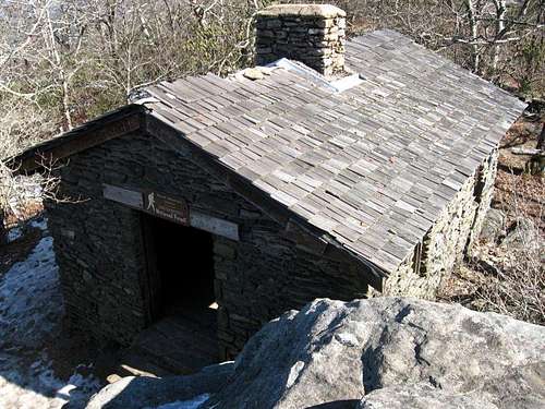
Historical building from 1934.

38.4 mile mark Whitley Gap Shelter


43.2 mile mark  Low Gap Shelter  built  up to be level.   Notice the Georgia style..


50.5 mile marker Blue Mountain Shelter


58.6 mile marker Tray Mountain Shelter


66 mile mark Deep Gap Shelter


71.4 mile mark  Plumorchard Gap Shelter


 Sign..


These shelters will lead you onto North Carolina..  at the 78.5 mile mark.


Springer Mountain

Here is where it all begins.. Sign in at Springer Mountain, Georgia. 3780 ft.  Chattahoochee National Forrest  Originally called Penitentiary Mountain for unknown reasons. Part of the Blue Ridge Mountain range.


File:Springer Plaque.jpg


The Appalachian Trail runs through 80 miles of Georgia.  The highest point is on Blood Mountain 4,461 ft.  Lowest point is at Dicks Creek Gap 2,675 ft.  


Along those 80 miles are many shelters for those of us who choose to stay on the trail.

Starting with Springer Mountain Shelter, it's where I hope to tent in the meadow my first night on the trail.   I begin in the morning to trek those 80 miles.  Hopefully, within a weeks time.


View from Springer Mountain


From Wiki:
Springer Mountain Shelter is located on a spur trail leading about 70 yards east of the Appalachian Trail. Blue blazes mark the spur trail. The trail junction is about 800 feet north of the brass plaque marking the southern terminus of the Appalachian Trail. The shelter has a raised first floor and a sleeping loft reached by a permanent ladder. Each level of the shelter can comfortably sleep four or five backpackers.
There is a fire circle and wooden picnic table in front (west) of the shelter. There is a three-walled privy down the hill directly behind the shelter. There is a piped spring about 30 yards (25 m) south of shelter. The spring has provided water even in recent drought years. There are two sturdy cables strung in trees near the shelter. Each is equipped with pulleys and hoisting lines for hauling backpacks and food bags out of reach of the local bears, raccoons and rodents.
There is a meadow with room for many tents near the intersection of the Appalachian Trail and the spur trail to the shelter. The meadow also has a fire circle.

It will be busy there the beginning of April.  I hope to get a tenting spot in the meadow that night.  My plan which will most likely change several times is to tent as much of the way as possible.  Hummingbird "tenting" the AT.. 


Georgia on my mind.. Amicalola Falls State Park

Welcome to Autumn!   It has been a very long while since I have written here.  It's getting close to the 6 month mark to take off!  I can't believe time has moved so quickly.  Yes, it will be here before I know it!

Good News!  I am now Ellie Baughman..  Rick and I have made that decision to become a married couple.  It's good.  The hike is still on and will have that added challenge of being apart.  A most difficult challenge.

Before I begin at Springer Mountain, I do plan to hike the Approach Trail in Amicalola Falls State Park. Named by the Cherokee meaning "tumbling waters".

The the Approach Trail includes the "Falls". Beginning at the Reflection Pond, with 604 staircase steps to the top of the Falls.  It's 8.5-miles to the Springer Mountain summit.   What a workout that will be to start on!  Ha.

I plan to spend the first night at the base of the Falls at the Max Epperson Shelter for thru hikers only.  That way, I can begin my hike early and get to the top of Springer Mountain to prepare for another early morning start. If I just can't make it to the top, there is the Black Gap Shelter 1.3 miles from Springer.

There is a visitor center for hikers to sign in and weigh their packs. There is also the "Arch" for that photo moment!


File:Amicalola-Falls Main Dawsonville-GA 01.jpg
Named by the Cherokee people, it is the beginning of the "Trail of Tears" when they were driven away to live in the Ozarks. 

http://www.southernhiker.com/wp-content/uploads/2008/12/img-1559.jpg


Tuesday, June 11, 2013

Good Morning..    I can't believe the time has gone by so quickly.  I've not been hiking as much as I would like to due to more work than usual.  That's not good but I do need to keep saving up for the hike.  My gear is looking good.

Made it to the REI members sale last Saturday.  I was in line at 5:30 with all the other eager members looking for a deal.  I got what I went for.  A pair of Merrill boots like the ones I have and love. Everything in the sale are returned items.  My boots were returned because they were too small for the woman who wore them once. $25.00.. an unbelievable price!  We all were allowed in the store in small groups at a time for only fifteen minutes.  What a scramble that was.. ha.  I went for the boots first and didn't see anything else that I didn't have already have.  No need to try and hoard things because of the price. 

I've been following the White Blaze and Trail Journal/forum sites everyday.  It appears that the rainy weather is causing the drop out of hikers.  It's been a wet year so far and may be "naturally" what it will be next year as well.  It doesn't rain much here (at least right now) but I would like to hike in the rain in my rain gear to see what it feels like with the extra bulk of a jacket and pants. Sharon and I got caught in a rain storm once on the trail.  We weren't dressed for it. got drenched and laughed about it once we were in the warm, dry car again.  There won't be any warm, dry car to jump into.  I hope that I will be able to keep my sleeping gear and inside of the tent as dry as possible.  I'll be looking for techniques that people are using that helps.

I'm feeling more positive about starting with the crowd in the beginning of April.   March starts may gain a little time, but that month later has to give a better chance of better weather.  Won't know until it happens.  Will need to learn some "sun" dances.. ha.

I hope to write more often.  I'm sure I will as time brings me closer and my excitement rises. I'm trying not to over talk the trail and drive people crazy.. ha.  It's coming up more often even if I don't initiate the conversation. 

Yes.. I'm going to do this.  God please guide me in my planning and the decisions I make. Though I am not a church going person, I do believe in God and that there will be times to ask for "strength" and times that the beauty around me can will bring God closer to me.

Hummingbird..  


Sunday, May 12, 2013

Happy Mother's Day 2013

Happy Mom's Day to all who are mother's to human children and to pets as well.  Being a dog walker,  I have had the fortune to know many pets who are as special as any child would be.

My celebrations with my children;  Sharon, Lou, Eric and Sina, will be today and tomorrow.  I'm looking forward to my special dinner!

My celebration with Rick was planting our vegetable garden with yellow squashes, purple eggplants, Japanese eggplant, green peppers, carrots, turnip, watermelon, honey dew melon, Swiss chard, radishes, butternut squash, zucchini, cauliflower, Brussel sprouts, cherry tomatoes and an already existing pumpkin plant (we believe that's what it is)  Ha..  I think that's everything.   WOW.. if it all grows in, we will have a feast in a few weeks. 


 I wish you all a wonderful day filled with love and sharing.

Indian Tribes that Lived and Traveled the Appalachian Trail

Cherokee - Georgia.. Amicalola Falls means "tumbling water".  Were driven away to the Ozarks.. beginning of the "Trail of Tears"

Cherokee- North Carolina. 

Penobscot - Maine  

State and National Forests Passed Through..

 Amicalola Falls State Park  8.5 miles, Georgia  Cherokee for "tumbling water".

Chattahoochee National Forest, Georgia   Cherokee for "flower painted rock".